FISHTERM bilingual dictionary Search results for 'Baseline' (3 record(s))
| RECORD No. | 244 |
| AUTHOR | ELAD D. F. |
| DATE OF CREATION | |
| LAST UPDATE | 2023-03-13 00:00:00 |
| FRENCH | |||||
| SUBJECT FIELD |
| ||||
| TERM | * Ligne de base archipélagique statut: préféré | ||||
| PART OF SPEECH | nom féminin | ||||
| DEFINITION |
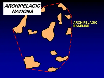
lignes de base droites reliant les points extreˆmes des îles les plus éloignées et des récifs découvrants de l’archipel à condition que le tracé de ces lignes de base englobe les îles principales et définisse une zone où le rapport de la superficie des eaux à celle des terres, atolls inclus, soit compris entre 1 à 1 et 9 à 1. Elle ne doit pas dépasser 100 milles marins; toutefois, 3 % au maximum du nombre total des lignes de base entourant un archipel donné peuvent avoir une longueur supérieure, n’excédant pas
125 milles marins. | ||||
| PLURAL | Lignes de base archipe´lagiques ; | ||||
| DEFINITION SOURCE |
The 1982 United Nations Convention on the Law of the Sea | ||||
| ENGLISH | |||||
| SUBJECT FIELD |
| ||||
| TERM | * Archipelagic baseline statut: préféré | ||||
| PART OF SPEECH | noun | ||||
| PLURAL | Archipelagic baselines ; | ||||
| DEFINITION |
baseline joining the outermost points of the outermost islands and drying reefs of an archipelago. It does not exceed 100 nautical miles, except that up to 3 per cent of the total number of baselines enclosing any archipelago may exceed that length, up to a maximum length of 125 nautical mile. | ||||
| DEFINITION SOURCE |
The 1982 United Nations Convention on the Law of the Sea | ||||
| RECORD No. | 227 |
| AUTHOR | ELAD D. F. |
| DATE OF CREATION | |
| LAST UPDATE | 2023-03-03 00:00:00 |
| ENGLISH | |||||||||||||
| SUBJECT FIELD |
| ||||||||||||
| TERM | * Baseline statut: préféré | ||||||||||||
| PART OF SPEECH | noun | ||||||||||||
| PLURAL | Baselines ; | ||||||||||||
| DEFINITION |
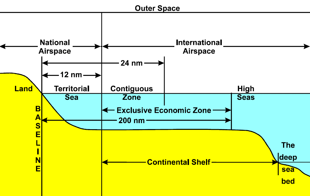
line along the coast of a coastal State as marked on large-scale charts officially recognised by the coastal State which acts as the starting point for measuring the breadth of the sea around a coastal state. | ||||||||||||
| DEFINITION SOURCE |
The 1982 United Nations Convention on the Law of the Sea | ||||||||||||
| USAGE EXAMPLE | " Except where otherwise provided in this Convention, the normal baseline for measuring the breadth of the territorial sea is the low-water line along the coast as marked on large-scale charts officially recognized by the coastal State. " (United Nations Convention on the Law of the Sea, article 5, paragraph 1); --- 2. " The contiguous zone may not extend beyond 24 nautical miles from the baselines from which the breadth of the territorial sea is measured. " (United Nations Convention on the Law of the Sea, article 33, paragraph 2) | ||||||||||||
| RECORD No. | 224 |
| AUTHOR | ELAD D. F. |
| DATE OF CREATION | |
| LAST UPDATE | 2023-02-19 00:00:00 |
| FRENCH | |||||||||||||
| SUBJECT FIELD |
| ||||||||||||
| TERM | * Ligne de base normale statut: préféré | ||||||||||||
| PART OF SPEECH | nom féminin | ||||||||||||
| DEFINITION |
la ligne à partir de laquelle est mesurée la largeur de la mer territoriale. Elle est la laisse de basse mer le long de la côte, telle qu’elle est indiquée sur les cartes marines à grande échelle reconnues officiellement par l’État côtier. | ||||||||||||
| PLURAL | Lignes de base normales ; | ||||||||||||
| DEFINITION SOURCE |
The 1982 United Nations Convention on the Law of the Sea | ||||||||||||
| USAGE EXAMPLE | 1. Convention des Nations Unies sur le droit de la mer, article 5, alinéa 1 : « Sauf disposition contraire de la convention, la ligne de base normale à partir de laquelle est mesure´e la largeur de la mer territoriale est la laisse de basse mer le long de la côte, telle qu’elle est indique´e sur les cartes marines à grande e´chelle reconnues officiellement par l’État côtier. » | ||||||||||||
| ENGLISH | |||||||||||||
| SUBJECT FIELD |
| ||||||||||||
| TERM | * Normal baseline statut: préféré | ||||||||||||
| PART OF SPEECH | noun | ||||||||||||
| PLURAL | Normal baselines ; | ||||||||||||
| DEFINITION |
the low-water line along the coast of a coastal State as marked on large-scale charts officially recognised by the coastal State. It is the starting point for measuring the breadth of the territorial sea of a coastal state. | ||||||||||||
| DEFINITION SOURCE |
The 1982 United Nations Convention on the Law of the Sea | ||||||||||||
| USAGE EXAMPLE | United Nations Convention on the Law of the Sea, article 5, paragraph 1 : " Except where otherwise provided in this Convention, the normal baseline for measuring the breadth of the territorial sea is the low-water line along the coast as marked on large-scale charts officially recognized by the coastal State. " | ||||||||||||
1. United Nations Convention on the Law of the Sea, article 3, paragraph 1:
" Every State has the right to establish the breadth of its territorial sea up to a limit not exceeding 12 nautical miles, measured from baselines determined in accordance with this Convention. "
2. United Nations Convention on the Law of the Sea, article 4, paragraph 1:
" The outer limit of the territorial sea is the line every point of which is at a distance from the nearest point of the baseline equal to the breadth of the territorial sea. "
3. United Nations Convention on the Law of the Sea, article 5, paragraph 1:
" Except where otherwise provided in this Convention, the normal baseline for measuring the breadth of the territorial sea is the low-water line along the coast as marked on large-scale charts officially recognized by the coastal State. "
4. United Nations Convention on the Law of the Sea, article 6, paragraph 1:
" In the case of islands situated on atolls or of islands having fringing reefs, the baseline for measuring the breadth of the territorial sea is the seaward low-water line of the reef, as shown by the appropriate symbol on charts officially recognized by the coastal State. "
5. United Nations Convention on the Law of the Sea, article 7, paragraph 1:
" 1. In localities where the coastline is deeply indented and cut into, or if there is a fringe of islands along the coast in its immediate vicinity, the method of straight baselines joining appropriate points may be employed in drawing the baseline from which the breadth of the territorial sea is measured. "
4. Images related to 'Baseline'


